Working with ECDIS has never been so easy!
An Electronic Chart Display and Information System (ECDIS) displays the information from Electronic Navigational Charts (ENC) and integrates multiple sensor information into a common display for maximum level of awareness.
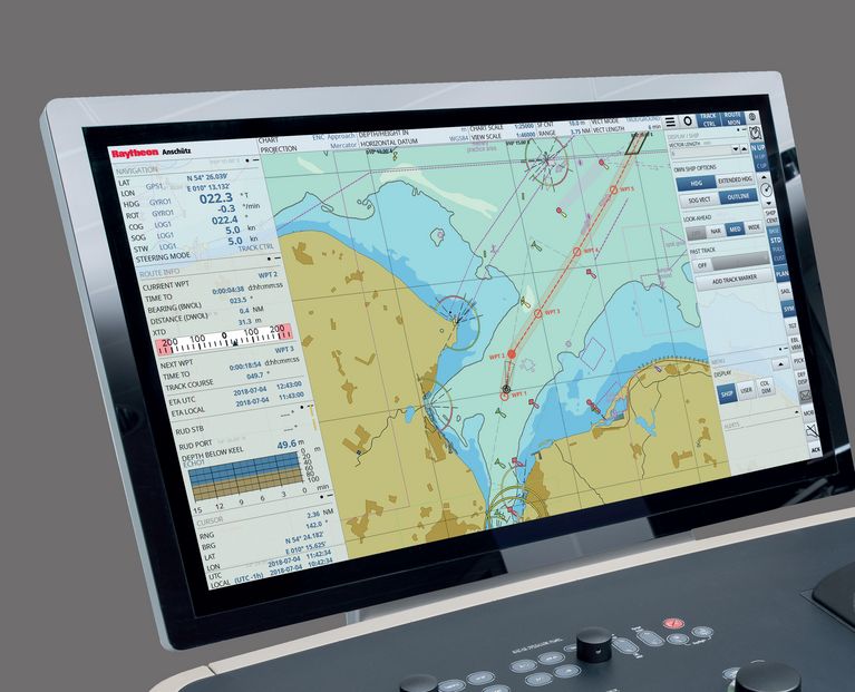
The first „user-defined“ ECDIS software, designed under continuous feedback from navigators. This makes the ECDIS NX intuitive to operate and it effectively supports the daily tasks and use cases of navigators.
Easy familiarization for crews
Intuitive to operate thanks to a modern, clear structured UI.
Multi-touch and intuitve interaction patterns like point-to-chart, drag and drop or retractable panels
Quick access bar and wizard guided workflows for standard use cases
Embedded online user manual and free online type-specific ECDIS training
Safe and efficient
Functions known from INS significantly contribute to safe navigation.
Optional integrated features, e.g. radar video overlay
Consistent use of qualified data and consistent alert handling
Navigators receive a validated picture of the prevalent situation for right decision making
Secure & futureproof investment
Ready for future: modular features and compliance with standards.
Future-proof hardware and operating system
Ongoing software compliance (e.g. new ECDIS test standards, such as S-100)
Growing scope of modular features, easy to update
Global service network in case you need help
Charts and standards
Chart formats / availability: S-57/S-63 ENCs, ARCS (option), BSB (option), DNC (option), military chart formats (option)
Type approved acc. to IEC 61174 Ed. 4.0 and IHO Presentation Library S-52 Annex A Edition 4.0 incl. DNV GL certificates
Type approved as Track Control System acc. to IEC 62065 Ed. 2 with Anschütz NP5400 / NP5500 autopilots
Compliant for paperless navigation in dual configuration
Features
Better situational awareness, less workload, ongoing compliance.
Retractable panels maximize view of the chart
Quick access bar for essential functions
Smart tools for voyage management, such as Wizard based route planning
ETA calculation and speed of advance (SAO) for individual waypoints
Graphical editing of routes, supported through intuitive interaction patterns
Editable look ahead zones for anti-collision, route monitoring and anti-grounding
Filtering tools to reduce unnecessary alarms
Support of Admiralty Information Overlay (AIO)
Plus Features
Optional chart formats (ARCS, BSB, DNC, Military)
Radar video overlay (RVO)
Geo objects events (ECA)
Search & rescue (SAR)
Electro-optical bearing (EOB) device
Target intercept
Charttable function